
Here’s another sample of the descriptive articles to be found in our latest book: Nova Scotia & PEI Armchair Adventures which can be found HERE.
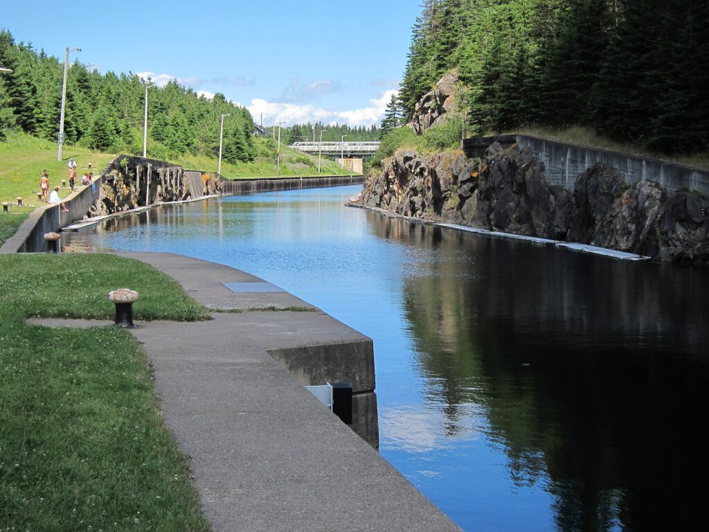
It was built to save sailors the trouble of going around Cape Breton Island. The St. Peter’s Canal cuts through the narrow isthmus at the southern end of Cape Breton, connecting the Bras d’Or Lake to the Atlantic Ocean at St. Peter’s Bay in just under a kilometre, and it was first proposed in the late 1700s as a shortcut that would allow vessels to avoid the long and dangerous passage around the island’s exposed southern and eastern shores. The canal that exists today was completed in 1869, making it one of the oldest operating canals in Canada, and it is still in use as a pleasure-craft waterway, with the original stone lock chambers lifting and lowering boats between the brackish Bras d’Or and the saltwater of the bay in a process that would have been entirely familiar to the men who built it.
Almost no one comes to watch.
That is the peculiar thing about the St. Peter’s Canal. It is a working piece of nineteenth-century marine engineering in almost original condition, operating on the same principle it has used for over a hundred and fifty years, and the small park along its banks on a weekday in July is likely to contain you, possibly a couple of local residents walking a dog, and the lockkeeper going about business with the unhurried competence of someone doing a job they understand completely. The lock gates are hand-operated, which is to say they are operated by a person turning a capstan, and watching a modern sailboat raised two metres in a stone chamber by a mechanism designed in the Victorian era is a specific and quiet pleasure that falls outside the categories of attraction that most travel writing knows how to describe.
The village of St. Peter’s itself is one of the oldest continuously settled European communities in Nova Scotia. Nicolas Denys, the French entrepreneur and colonial administrator who wrote one of the most important early accounts of Acadian life, established a trading post here in 1650, and the landscape around the canal entrance still carries the ghost of that settlement in the names and the layout of the land. The Canal National Historic Site includes a small museum in a restored lock-keeper’s house that tells the story of both the French and English periods of settlement with more honesty and nuance than most heritage sites manage, in part because the community it serves is small enough that everyone knows the real history and would notice if it were softened.
One fact about the St. Peter’s Canal that most people, including most Nova Scotians, do not know: the Mi’kmaq had used the same isthmus as a portage route for centuries before Europeans arrived, carrying their canoes between the Bras d’Or and the Atlantic to avoid the exposed ocean passage. The canal that the Victorians built through this narrow neck of land was, in that sense, a formalization in stone and timber of a route that had existed in Mi’kmaw navigation knowledge for a very long time. The portage at St. Peter’s appears in early Mi’kmaw oral history, and the name Potlotek, used for the nearby Eskasoni First Nation reserve, reflects the deep roots of this community’s relationship with the landscape of the southern Bras d’Or.
Walking the towpath alongside the canal on a calm summer morning, with the Bras d’Or glittering to the north and the open bay visible to the south and a fishing boat from the bay working its way up toward the lock, is the kind of experience that belongs to slow travel at its most rewarding. Nothing is rushing. The lock fills in its own time. The lockkeeper is not performing; he is working. The water is doing what water does in a narrow stone channel, reflecting the sky and moving with a quiet determination that has nothing to do with the observer.
The town of St. Peter’s has the modest, purposeful character of a community that has been at a geographic junction long enough to feel no need to explain itself. There is a good bakery. There is a hardware store. There is a Legion. The MacAskill House Museum, just up the hill from the canal, commemorates Wallace MacAskill, the Cape Breton photographer who produced the iconic images of the Bluenose schooner in the 1920s and 1930s, the photographs that defined the visual identity of the vessel that still appears on the Canadian dime. MacAskill grew up in St. Peter’s and his eye for the sea, for the particular quality of light on dark water and the weight of working sail against a grey Nova Scotia sky, was formed on the waters visible from this town.
Richmond County, which surrounds St. Peter’s, is one of the least-visited counties in Nova Scotia and one of the most geographically interesting, occupying the southern end of Cape Breton between the Bras d’Or and the open Atlantic, with a coastline that includes the Isle Madame archipelago, the Lennox Passage, and long stretches of shore that face both east and south into the open ocean. The canal sits at the hinge of this geography, and understanding the landscape of the county almost requires standing at the canal and looking in both directions at once.
If you find yourself driving through Cape Breton on the Trans-Canada and wondering what is down the road to the right just before the Canso Causeway, the answer involves a Victorian canal, a Mi’kmaw portage route, one of Canada’s oldest European settlements, and the photographs that put the Bluenose on the national currency. Turn right.
Our book is available in either Kindle or paperback HERE.